Unveiling The Iranian Plateau: Cradle Of Civilizations & Rugged Beauty
The Iranian Plateau, often referred to as the Persian Plateau, stands as a monumental geological feature spanning vast stretches of Central Asia, South Asia, and Western Asia. This immense landmass, central to the identity and history of Iran, is far more than just a geographical location; it is a tapestry woven from ancient civilizations, dramatic landscapes, and a unique cultural heritage that has profoundly shaped human history. From its formidable mountain ranges to its arid plains, the Iranian Plateau has served as a crucible for human development, bearing witness to millennia of human ingenuity and resilience.
This article delves into the multifaceted nature of the Iranian Plateau, exploring its geological origins, its diverse topography, the climate that defines its habitable zones, and its unparalleled historical and cultural significance. We will uncover how this rugged, mountainous, and ethnically diverse region has fostered a distinctive way of life, influencing everything from ancient empires to modern-day Iran. Prepare to journey through a land where geology meets destiny, and where the echoes of a glorious past resonate through a vibrant present.
Table of Contents
- What is the Iranian Plateau? Defining a Geological Marvel
- The Rugged Landscape of the Iranian Plateau
- Climate and Water: Shaping Life on the Plateau
- A Cradle of Civilization: Ancient Roots of the Iranian Plateau
- Cultural Continuity and Diversity Across the Plateau
- Modern Iran: The Plateau's Contemporary Significance
- Enduring Challenges and Future Outlook
What is the Iranian Plateau? Defining a Geological Marvel
The Iranian Plateau, often interchangeably called the Persian Plateau, is a vast and complex geological feature that forms a significant part of the Eurasian Plate. Its unique position, wedged between the Arabian and Indian plates, makes it a dynamic region of immense geological activity. This colossal landform isn't just confined to the modern borders of Iran; its influence stretches across a broader historical and geographical expanse, encompassing parts of the Caucasus, Central Asia, South Asia, and West Asia. Understanding the Iranian Plateau begins with grasping its immense scale and its pivotal role in the Earth's tectonic movements.Geographical Extent and Boundaries
Geographically, the Iranian Plateau is a sprawling entity, roughly outlined by a quadrangle formed by the cities of Tabriz, Shiraz, Peshawar, and Quetta. This vast area covers approximately 3,700,000 square kilometers (1,400,000 sq mi), encompassing the greater part of Iran, Afghanistan, and Pakistan west of the Indus River. It represents a large area of inland (endoreic) drainage in central Iran, characterized by its distinct boundaries. To the north, it is bounded by the majestic Alborz Mountains, while the west and south are defined by the formidable Zagros Mountains. To the east, a series of ranges collectively referred to as the Eastern Iranian Highlands mark its extent. The plateau itself is impressive in its dimensions, stretching about 1,000 km in length from northwest to southeast and approximately 600 km in width. This immense scale underscores its significance not only as a geological formation but also as a historical region, which has traditionally included Parthia, Media, and Eastern Persia—the very heartlands of Greater Persia.A Tectonic Crossroads: Eurasian, Arabian, and Indian Plates
At its core, the Iranian Plateau is a direct consequence of powerful tectonic forces. It is the part of the Eurasian plate that has been intensely deformed by the ongoing collision between the Arabian and Indian plates. This geological "sandwich" effect has resulted in a highly unstable geology, leading to frequent earthquakes across the region. The immense pressure exerted by these converging plates has sculpted the plateau's rugged and elevated landscape. The northwestern Iranian Plateau, particularly where the Pontic and Taurus mountains converge, exemplifies this ruggedness. This area boasts higher elevations, a more severe climate, and greater precipitation compared to the Anatolian Plateau, showcasing the dramatic impact of these tectonic interactions. The continuous geological activity is a defining characteristic of the Iranian Plateau, constantly reshaping its terrain and influencing its natural hazards.The Rugged Landscape of the Iranian Plateau
Iran is globally recognized as one of the world's most mountainous countries, and this characteristic is largely attributed to the nature of the Iranian Plateau. The landscape is overwhelmingly dominated by rugged mountain ranges that serve to separate various basins or plateaus from one another. This unique topography has profoundly influenced human habitation, lifestyles, and the types of dwellings found across the region. With most of the land being above 1,500 feet (460 m), the country's elevation contributes significantly to its diverse climatic zones and ecological systems. The central plateau itself is a tectonic plate that forms a basin, surrounded by several tall, heavily eroded mountain ranges, further emphasizing the rugged and complex nature of this land.Mountains and Basins: Iran's Dominant Topography
The defining feature of the Iranian Plateau's landscape is the intricate interplay between towering mountain ranges and the basins or plateaus they enclose. This geological pattern creates a series of isolated pockets, each with its own microclimate and distinct geographical characteristics. These deep gorges and defiles, unnavigable rivers, empty deserts, and impenetrable *kavīrs* (salt deserts) have historically contributed to a sense of insularity and tribalism among the Iranian peoples. As a result, the population has become concentrated in more habitable, often fertile, basins nestled within the mountainous terrain. This concentration of population in specific areas is a direct consequence of the challenging topography and the availability of water resources, which are scarce in many parts of the plateau. The central plateau, in particular, showcases this basin-and-range structure, acting as a natural amphitheater enclosed by geological giants.Key Mountain Ranges: Zagros, Alborz, and Caucasus
The most populous western part of the Iranian Plateau is particularly mountainous, featuring some of the most prominent ranges in the region. Among these, the Zagros Mountains form a vast natural barrier along the western and southwestern borders of the plateau, stretching for hundreds of kilometers. To the north, the Alborz Mountains stand as a formidable wall, containing Mount Damavand, which at 5,610 meters (18,406 feet) is Iran's highest point and a stratovolcano with significant cultural and mythological importance. Further to the northwest, the influence of the Caucasus Mountains is also felt, contributing to the rugged and elevated terrain. These mountain ranges are not merely geographical features; they are integral to the identity of the Iranian Plateau, influencing everything from climate patterns to human migration and settlement over millennia. Their sheer scale and ruggedness make them both a challenge and a source of natural beauty and resources for the inhabitants of the plateau.Climate and Water: Shaping Life on the Plateau
The climate of the Iranian Plateau is predominantly arid, a condition resulting from a confluence of several parameters. The geographical location of the Iranian Plateau itself plays a crucial role, positioning it within a dry belt. General atmospheric circulation patterns, particularly the dominance of the Subtropical High Pressure (STHP) system during the warm season, significantly contribute to the aridity. The rain shadow effect, created by the surrounding high mountain ranges like the Zagros and Alborz, prevents moisture-laden winds from reaching the interior of the plateau. Furthermore, the continental condition of the plateau, coupled with its considerable distance from oceans, limits the sources of moisture, leading to sparse precipitation. This combination of factors results in a harsh, dry climate across most areas, making water an incredibly precious resource. The topography and water supply are the primary determinants of regions fit for human habitation on the Iranian Plateau. Where water is scarce, settlements are sparse, and lifestyles are adapted to conserve every drop. Conversely, areas with reliable water sources, often fed by mountain snowmelt or underground qanats, become centers of population and agricultural activity. The deep gorges and defiles, along with the unnavigable rivers and vast empty deserts, including the impenetrable *kavīrs* (salt flats), have historically contributed to the insularity and tribalism among the Iranian peoples. These natural barriers made travel and communication difficult, fostering distinct local cultures and communities. Interestingly, studies suggest that a hotter Iran, potentially influenced by global climate change, could lead to increased monsoon flow on the Indian subcontinent, highlighting the interconnectedness of regional climate systems and the potential for future shifts in precipitation patterns.A Cradle of Civilization: Ancient Roots of the Iranian Plateau
The Iranian Plateau holds an undeniable claim as a cradle of civilization, with evidence suggesting human habitation since the Lower Palaeolithic period. This deep historical lineage underscores its importance in the broader narrative of human development. Over millennia, the plateau became a vibrant stage for the emergence and flourishing of complex societies, leaving behind a rich archaeological legacy. The topography and the availability of water have always been key factors in determining where these early civilizations could thrive, with settlements often concentrated in fertile basins near reliable water sources. The plateau's historical significance is profound, encompassing regions that were the heartlands of Greater Persia, including Parthia, Media, and Eastern Persia. These ancient kingdoms and empires, particularly those dating back to the Achaemenian period which began in 550 BCE, laid the foundations for a distinctive cultural and social continuity that persists to this day. Halfway through this ancient era, the Iranian Plateau experienced a notable florescence of urbanism. Regions like Hissar, Yahya, and Jiroft developed into significant urban centers, intricately connected to Central Asia and beyond via extensive commercial networks. These early cities were hubs of trade, innovation, and cultural exchange, demonstrating the plateau's role as a dynamic crossroads of ancient world. The archaeological discoveries from these sites continue to reveal the sophistication and complexity of these early societies, highlighting their contributions to art, architecture, and social organization. The Iranian Plateau is not just a geological formation; it is a living museum of human history, where every layer of soil tells a story of ancient peoples, their struggles, and their triumphs.Cultural Continuity and Diversity Across the Plateau The Iranian Plateau is renowned for maintaining a rich and distinctive cultural and social continuity that stretches back thousands of years, specifically dating from the Achaemenian period in 550 BCE. This enduring heritage is deeply intertwined with the geographical elements of the plateau, which have shaped the unique lifestyles and traditions of its inhabitants. The rugged mountain ranges, vast deserts, and isolated basins have fostered a remarkable diversity among the Iranian peoples, leading to a mosaic of languages, customs, and artistic expressions. The insularity created by the plateau's challenging terrain, with its deep gorges and impenetrable *kavīrs*, has contributed to the preservation of distinct tribal and regional identities. Despite this, a unifying cultural thread runs through the diverse communities, largely rooted in the ancient Persian legacy. Iran, officially an Islamic Republic since 1979, has developed a unique brand of Islamic governance, yet it continues to honor and integrate its pre-Islamic heritage. The official websites of Iran, for instance, provide extensive links and information on Iran's art, culture, geography, history, travel, and tourism, underscoring the nation's pride in its deep historical roots. From ancient poetry to intricate handicrafts, the cultural richness of the Iranian Plateau is a testament to its long and complex history, constantly evolving yet firmly anchored in its past. This blend of ancient traditions and contemporary expressions makes the cultural landscape of the Iranian Plateau truly captivating.
Modern Iran: The Plateau's Contemporary Significance
In the modern era, the Iranian Plateau continues to be the heartland of Iran, a sovereign nation occupying an area of 1,648,195 sq km. As an Islamic Republic, Iran is divided into five regions with 31 provinces, with Tehran serving as the nation's capital, largest city, and financial center. The rugged topography of the plateau, characterized by its plateaus and mountains, remains a defining feature of the country, influencing its infrastructure, economy, and population distribution. The populous western part, with its prominent ranges like the Zagros, Alborz, and Caucasus, continues to be the most densely inhabited. The contemporary significance of the Iranian Plateau extends beyond its geographical boundaries. Iran, a mountainous, arid, and ethnically diverse country of Southwestern Asia, plays a crucial role in regional and international affairs. Keeping informed with AP News, for instance, allows observers to get the latest news from Iran as it happens, from articles to the latest videos, covering politics news headlines and more. The unique brand of Islamic Republic that Iran has become known for since 1979 adds another layer to its modern identity, shaping its foreign policy, social norms, and internal dynamics. The plateau, therefore, is not just a historical relic but a vibrant, active landscape that underpins the modern Iranian state, its challenges, and its aspirations.Enduring Challenges and Future Outlook
The Iranian Plateau, despite its rich history and cultural depth, faces a myriad of enduring challenges, many of which are intrinsically linked to its unique geographical and climatic conditions. The pervasive aridity, a result of its location, atmospheric circulation, rain shadow effect, and continental isolation, remains a fundamental concern. Water scarcity is a critical issue, directly impacting agriculture, urban development, and the daily lives of its population. The topography, while beautiful, also presents logistical challenges, with deep gorges and defiles, unnavigable rivers, and vast deserts contributing to isolation in many areas. Furthermore, the highly unstable geology, a direct consequence of being wedged between major tectonic plates, means that frequent earthquakes are a constant threat. This geological instability necessitates robust infrastructure planning and disaster preparedness. Looking ahead, the future of the Iranian Plateau will undoubtedly be shaped by how these challenges are addressed. Sustainable water management, resilient infrastructure development, and adaptation to potential climate shifts (such as the implications of a hotter Iran on monsoon flows) will be crucial. Despite these hurdles, the Iranian Plateau's long history of human resilience and adaptation suggests a capacity to navigate future complexities. Its strategic location, rich natural resources, and deeply rooted cultural heritage will continue to define its trajectory on the global stage.Conclusion
The Iranian Plateau is a testament to the profound interplay between geography, history, and human civilization. From its ancient origins as a cradle of civilization, inhabited since the Lower Palaeolithic, to its role as the heartland of modern-day Iran, this rugged and diverse land has shaped empires, cultures, and destinies. We've explored its unique geological formation, its defining mountain ranges like the Zagros and Alborz, and the arid climate that has dictated human settlement patterns for millennia. The enduring cultural continuity, dating back to the Achaemenian period, stands as a remarkable testament to the resilience and ingenuity of the peoples who have called this plateau home. Understanding the Iranian Plateau is key to appreciating the complexities of Iran itself – a nation of profound historical depth and contemporary significance. Its geographical features are not merely backdrops but active participants in its story, influencing everything from its ancient urban centers to its modern political landscape. We hope this comprehensive exploration has provided you with a deeper insight into this remarkable part of the world. What aspects of the Iranian Plateau intrigue you the most? Share your thoughts in the comments below, or explore more of our articles to delve deeper into the rich tapestry of world history and geography.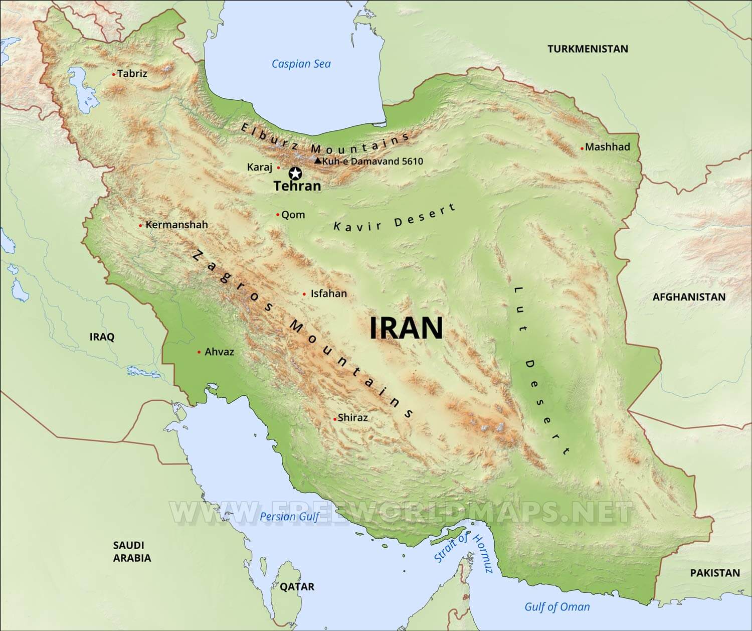
Iranian Plateau Map

Iranian Plateau Map

Unveiling The Iranian Plateau: A Geological And Cultural Tapestry
